DRONEMESH · LOCAL WORKSTATION
Mission processing
Outputs
AeroClear now has a broader aviation-data picture through FAA SWIM integration. DroneMesh, TacWing-X and CloneCode are advancing across drone-data production, UAS operations and local AI software engineering.
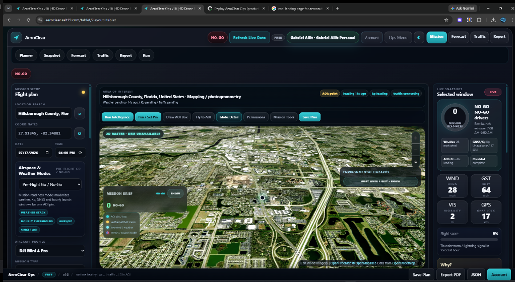
AeroClear already brings weather, GNSS and space-weather context, terrain, aircraft limits, nearby cooperative crewed-aircraft awareness, launch-window analysis, mission geography and flight reporting into one responsive planning surface. FAA System Wide Information Management (SWIM) integration broadens the aviation information available alongside those mission-planning tools.
For a pilot, the value is a more complete operational picture in one place instead of stitching together disconnected sources before a flight.
DroneMesh is a private, local-first photogrammetry workstation built around a familiar desktop workflow: bring in flight imagery, watch processing advance, review outputs, and export the finished project without requiring SALT19-hosted GPU processing or routine customer imagery storage.
The current application surface covers orthomosaics, DSM/DEM and DTM products, hillshade, LAZ/LAS/XYZ point clouds, OBJ mesh geometry, DXF/SHP contours, reports and offline handover packages. Processing progress is visible in the application, and a local Qwen assistant can help users interact with the project through Ollama.
TacWing-X is an Android operator display and edge-autonomy foundation built around a vendor-neutral runtime. Its current physical validation target is DJI Air 2S with DJI Smart Controller RM500, using DJI Mobile SDK V4. The wider architecture is designed around platform adapters so future integrations do not require rebuilding the operator interface.
The current HUD surface is designed to keep live video where supported, heading and attitude, speed and altitude, resilient PNT integrity, confidence and drift, platform position, battery and link quality, obstacle and camera state where available, local ONNX perception overlays, world-track counts and freshness watchdogs visible to the operator.
CloneCode combines a modern coding workspace with local model routing, repository-aware context, editor and LSP intelligence, Git review, persistent sessions, skills, memory, connectors and governed agent workflows. It works with Ollama, LM Studio and optional loopback OpenAI-compatible local endpoints.
The primary workbench exposes Ask, Plan, Agent and Sandbox Agent modes beside the editor and assistant. Its coding loop is designed around reviewable evidence: plan, RED proof, implementation, GREEN, independent review and fresh verification rather than silently treating a generated patch as finished work.
AeroClear focuses on the mission environment before and around flight. DroneMesh turns aerial imagery into deliverables after collection. TacWing-X moves closer to the operational aircraft and robotic layer. CloneCode applies the same emphasis on local execution, explicit authority and verification to software engineering.
Agent Utility Grid supplies machine-accessible technical services, while EvoMind continues the underlying research into persistent reasoning, memory, planning, governed execution and verified outcomes. The result is a portfolio spanning cognition, infrastructure, field operations and production work rather than a collection of disconnected demos.